http://eunahris.blogspot.com/2007/12/china-sars.htm
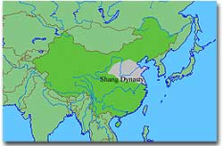
The land of the Shang Dynasty had many geographic features. The features had impacts on the dynasty. The Shang Dynasty was located on the northern part of the Pacific Ocean. The ocean gave a supply of fish, and other forms of food, along with transportation. The water gave an abundance of fish and other animals, along with ocean plants for eating. This supported the population, allowing the dynasty to grow and prosper. The Yangtze and Yellow Rivers followed through the Shang Dynasty. The rivers often flooded. Because of the flooding, systems of irrigation and flood control were created. With a controlled amount of water coming to the farmer's land, it was less likely to loose crops. Therefore, there was always food. The river also gave farmers water for their crops, which helped support the food supply needed. To the north of the Shang Dynasty was the Gobi dessert. This desert protected the dynasty from intruder from the north. This natural barrier allowed the people of the Shang Dynasty to not spend their time on worrying about intruders in the north. Instead the people could improve what they had and invent new things.
<http://ushistory.org/civ/9b.asp>
No comments:
Post a Comment